Inner West Rezoning
Inner West Rezoning Explained: TOD, Low and Mid-Rise and Our Fairer Future
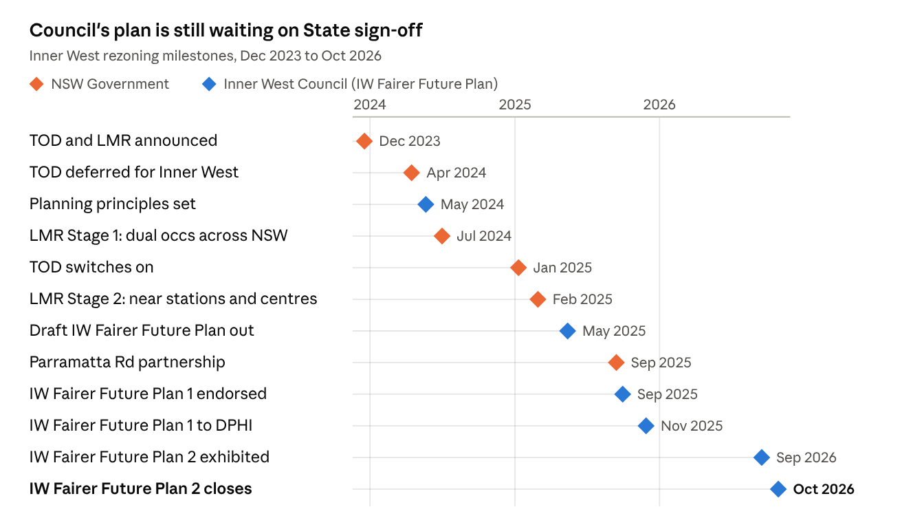
Two State Government housing reforms changed the planning rules around Inner West train stations in early 2025. Inner West Council responded with its own plan called the IW Fairer Future Plan, which is still waiting on State approval. It's complex and complicated, but here is a simplified run down on what's happened so far and what it means for buyers purchasing in the Inner West.
The important bits:
- State rules apply now. The TOD and Low and Mid-Rise (LMR) controls have been in force in the Inner West since January and February 2025.
- IW Fairer Future Plan 1 is waiting on State sign-off. Council's alternative to the State rules: taller buildings (mostly 6 to 11 storeys) in fewer, selected spots around Marrickville, Dulwich Hill and Ashfield, instead of a blanket 6 storeys near the stations. Council endorsed it on 30 September 2025 and sent it to the State on 28 November 2025. Details in Stage 2 below.
- IW Fairer Future Plan 2 Currently open for feedback, It does not replace Plan 1, it adds to it. It covers suburbs Plan 1 left out (such as Annandale, Enmore, Newtown, Balmain, Rozelle, Lilyfield and Croydon) and sites Plan 1 held back for more work. Have your say.
- Parramatta Road is being rezoned by the State for up to 8,000 homes, with a draft due late 2026.
Check your address: the official maps
The fastest way to see what could change on a street is to look it up. These free government maps show it property by property.
Timeline
Stage 1: The State reforms are announced (Dec 2023 to Feb 2025)
In December 2023 the NSW Government announced two reforms to put more homes near transport and shops.
What was introduced
- Transport Oriented Development (TOD): apartment buildings up to 6 storeys within 400 m of Ashfield, Croydon, Dulwich Hill and Marrickville stations, overriding local height and density limits. This includes heritage conservation areas; only individually heritage-listed properties are excluded.
- Low and Mid-Rise Housing (LMR): in force since 28 February 2025. Within 800 m walk of nominated stations and town centres, owners can now apply to build terraces, townhouses and small 2 storey blocks of 3 to 4 units on land previously limited to houses, and apartment buildings of 3 to 6 storeys on medium and high density land. Each project still needs development approval. Inner West centres include Annandale (Booth Street), Ashfield, Croydon, Dulwich Hill, Marrickville, Petersham, St Peters and Stanmore. It applies in heritage conservation areas (heritage streets), with only individually heritage-listed properties, high aircraft noise land and land near pipelines excluded.
- Bays West: named a separate State-led precinct near Rozelle.
Key decisions
- Apr 2024: the Planning Minister deferred the Inner West TOD stations so Council could prepare its own plan.
- Dec 2024: Council's request for a further deferral was refused.
- 10 Jan 2025: TOD switched on for Ashfield, Dulwich Hill and Marrickville (Croydon on 31 Jan).
- 28 Feb 2025: LMR Stage 2 switched on. This is the main part of LMR: townhouses, small unit blocks and 3 to 6 storey apartments allowed within 800 m of nominated stations and town centres (above). Stage 1, in mid 2024, had only allowed dual occupancies (two homes on one block) in low density zones across NSW.
Check which lots are affected on the NSW Planning Portal Spatial Viewer (Housing SEPP layers).
Stage 2: Council's alternative, IW Fairer Future Plan 1 (May 2024 to Nov 2025)
Council argued the State rules were one-size-fits-all and unlikely to get built, so it drafted its own plan to replace them (Council's approach).
Key decisions and changes
- May 2024: planning principles set: protect high value heritage areas, put density on main streets, no upzoning of Haberfield.
- 14 May 2025: draft released, around 35,000 homes, mostly 6 to 11 storeys around Marrickville, Dulwich Hill, Ashfield and Croydon.
- May to Jul 2025: exhibited, more than 3,000 submissions. Croydon deferred for joint work with Burwood Council.
- 14 Sep 2025: partnership with the NSW Government to rezone Parramatta Road for up to 8,000 homes.
- 30 Sep 2025: Plan 1 adopted. About 5,000 homes moved from Marrickville, Dulwich Hill and Ashfield to Parramatta Road; some sites deferred to Plan 2 (Council release).
- 28 Nov 2025: Plan 1 (around 27,000 homes) sent to DPHI, asking for TOD and LMR to be switched off in the Inner West.
Also in Plan 1: a 3% affordable housing contribution in upzoned areas, churches and faith-based groups able to develop if 30% is social housing, and around 350 social homes on five Council car parks (fact sheet).
Map: IW Fairer Future Plan 1 interactive map. Council notes it cannot be relied on until the State approves the plan.
Stage 3: IW Fairer Future Plan 2 and Parramatta Road (2026)
Plan 2 picks up the areas Plan 1 did not cover or deferred. Council flagged this second stage when it first exhibited the draft in May 2025.
Key decisions and changes
- 25 Feb to 7 Apr 2026: early community feedback on the Parramatta Road rezoning.
- 13 Apr 2026: Plan 1 amended while with the State.
- 15 Sep 2026: Council resolves to exhibit Plan 2.
- 16 Sep to 28 Oct 2026: Plan 2 on exhibition. It covers parts of 15 suburbs (Annandale, Ashfield, Balmain, Croydon, Dulwich Hill, Enmore, Leichhardt, Lewisham, Lilyfield, Marrickville, Newtown, Petersham, Rozelle, Stanmore and St Peters), the Croydon and Iron Cove precinct, and deferred Plan 1 sites. It also proposes an Iron Cove to Ashfield GreenWay.
- Dec 2026: revised Plan 2 goes back to Council.
- Late 2026: DPHI expects to exhibit the Parramatta Road rezoning.
Map: IW Fairer Future Plan 2 interactive map (how to use it).
Plan 1 vs Plan 2
What it means if you are buying in the Inner West
- Check the specific property, not the suburb. Neighbouring streets can sit under very different controls. Use both Council maps and the State's Spatial Viewer.
- Think about what could go up next door. A quiet street near a station may see 6 to 11 storey buildings in future.
- Uplift needs neighbours. Most sites must combine with adjoining lots to unlock the bigger heights.
- Expect more change. Plan 2 and Parramatta Road will both shape the area before the end of 2026.
Buying in the Inner West and not sure how rezoning affects a property you are looking at? Get in touch with Sourced Property and we will help you work through it before you make an offer.
This article is general information only and current as at October 2026. Planning controls change, so always confirm with Council, DPHI or a planning professional before you buy.

Similar articles
Heading
Looking to buy in the Inner West?
Book a 15 minute call and we’ll talk through what you’re looking for, the areas you’re considering, and how to approach the search.